Ben Lawers is the highest peak in the southern Highlands, famed for its arctic-alpine plants, stunning views, and rewarding hill walks for all abilities.
Ben Lawers (1,214m / 3,983ft) is the highest peak in the southern Highlands and the 10th highest mountain in Scotland. It dominates the northern skyline of Loch Tay and is the centrepiece of the Ben Lawers National Nature Reserve — a 9,500-hectare area managed by the National Trust for Scotland (NTS) that is internationally renowned for its arctic-alpine plant communities. For hillwalkers, botanists, photographers, and anyone who simply loves wild mountain landscapes, Ben Lawers is one of the most rewarding mountains in Britain.
The mountain’s combination of height, accessibility, botanical significance, and sweeping summit views makes it one of the most climbed Munros in Scotland. Yet even on a busy summer weekend, the vastness of the terrain means you can quickly find solitude once you leave the main path.
Why Ben Lawers Is Special
The Arctic-Alpine Flora
Ben Lawers is, quite simply, one of the most important botanical sites in Britain. The mountain’s underlying rock is calcareous mica-schist — a lime-rich geology that, combined with the high altitude, north-facing aspects, and persistent snow cover, creates conditions remarkably similar to those found in the Arctic tundra and the Alps. This has allowed an extraordinary community of arctic-alpine plants to survive here since the last Ice Age — species that retreated to these high, cold refugia as the climate warmed and have clung on ever since.
The list of rare species found on Ben Lawers reads like a botanist’s wish list:
- Alpine gentian (Gentiana nivalis) — One of Britain’s rarest wildflowers, with tiny, intensely blue flowers that bloom in July and August on the high crags
- Alpine saxifrages — Several species, including the rare Saxifraga cernua (drooping saxifrage) and Saxifraga nivalis (alpine saxifrage)
- Mountain pansy (Viola lutea) — Bright yellow and purple flowers carpeting the lower slopes in June
- Snow gentian — Found on the high ledges above 900m, flowering in late summer
- Globe flower (Trollius europaeus) — Golden globes of flower in damp flushes during June
- Mountain avens (Dryas octopetala) — A low-growing shrub with white flowers found on lime-rich ledges
- Alpine forget-me-not, moss campion, roseroot, and mountain sorrel — All part of the rich tapestry of plants on the upper slopes
The NTS has worked for decades to protect and restore these plant communities, fencing off vulnerable areas from grazing sheep and deer, and carrying out careful habitat management. The results are visible in the lush, flower-rich slopes during summer, particularly on the north-facing crags between Beinn Ghlas and the summit of Ben Lawers itself.
Important: Please stay on marked paths where they exist, and avoid trampling the fragile vegetation on the high crags. Many of these species are found in only a handful of locations in Britain, and even light foot traffic can damage them.
The Views
On a clear day, the summit panorama from Ben Lawers is extraordinary and ranks among the finest in Scotland. You can see:
- Ben Nevis (1,345m) and the Mamores to the northwest — Scotland’s highest mountains visible as a distant serrated skyline
- The Cairngorms to the northeast — The broad plateau of Cairn Gorm, Ben Macdui, and Braeriach
- The Forth Estuary and even the Bass Rock to the southeast — On exceptionally clear days, the volcanic plug in the Firth of Forth is visible over 70 miles away
- Ben Lomond and the Arrochar Alps to the southwest — The “bonnie banks” of Loch Lomond’s mountains
- Schiehallion — The distinctive conical peak to the northeast, one of Scotland’s most recognisable mountains
- Rannoch Moor — The vast, desolate plateau visible to the west
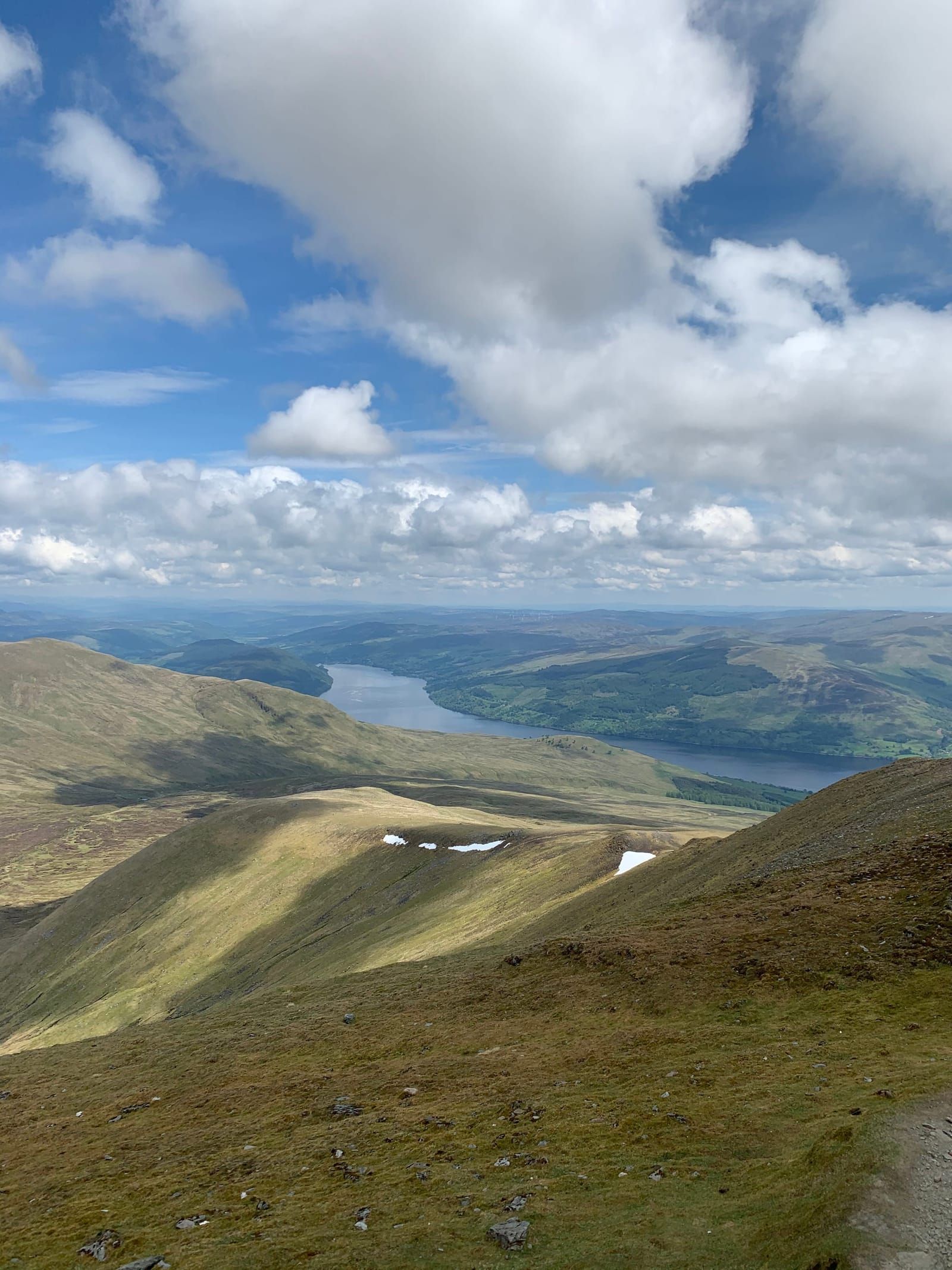
- Loch Tay itself — Stretching out far below like a silver ribbon, with the villages of Killin and Kenmore just visible at either end
The views change dramatically with the seasons. Winter offers the clearest air and snow-covered horizons stretching to infinity. Summer brings haze but also the lush green of the lower slopes. Autumn delivers golden light and the rich colours of heather and bracken.
The Accessibility
For a Munro of this height, Ben Lawers is remarkably accessible. The NTS car park sits at around 450m altitude on the minor road between the A827 (Loch Tay north shore road) and Bridge of Balgie in Glen Lyon. This gives you a significant head start — you’re already nearly 40% of the way to the summit before you take your first step. A fit walker can reach the top in 2.5–3 hours via the well-maintained path, making this one of the most achievable “high” Munros in Scotland.
The Main Summit Route: Step by Step
Ben Lawers via Beinn Ghlas (from the NTS Car Park)
- Distance: 8.5 km (5.3 miles) return
- Total Ascent: 870m (2,854ft)
- Time: 5–6 hours round trip
- Grade: Challenging (Munro — sustained ascent on mountain terrain)
- Munros bagged: 2 (Beinn Ghlas, 1,103m, and Ben Lawers, 1,214m)
This is the classic route and the one walked by the vast majority of visitors. It bags two Munros in a single outing and is well-maintained throughout, though the upper sections require confidence on steep, rocky ground.
Step 1: The NTS Car Park to the Nature Trail Junction (20 minutes) From the car park (grid ref: NN 608 379), follow the clearly signed path that heads north up the hillside. The path is well-constructed with stone steps and drainage channels, making the initial ascent comfortable. After about 15 minutes, you pass the junction with the NTS nature trail — a lower-level loop worth doing on a separate visit.
Step 2: Nature Trail Junction to the Beinn Ghlas Ridge (45–60 minutes) The path continues northward, climbing steadily through open moorland rich with wildflowers in summer. The gradient is persistent but never punishing. As you gain height, views open up behind you — Loch Tay stretches out below, and the hills of Glen Lyon appear to the north. The path curves gradually to the northeast, following the broad ridge that leads to Beinn Ghlas.
Step 3: The Beinn Ghlas Summit (1,103m) (30–45 minutes from the ridge) The final section to Beinn Ghlas steepens noticeably, with the path zigzagging up through rocky ground. The summit is marked by a small cairn and offers superb views in all directions. Many walkers stop here for a rest and a snack, enjoying the sense of achievement — Beinn Ghlas is a Munro in its own right. If the weather has closed in or you’re running low on energy, this makes a perfectly satisfying objective to turn around at.
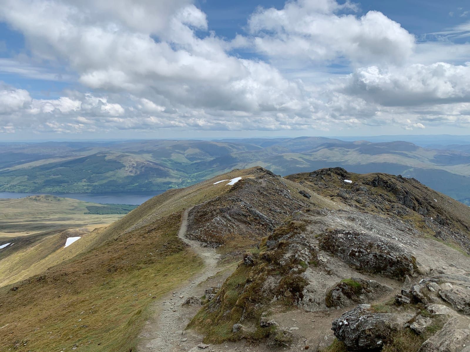
Step 4: Beinn Ghlas to Ben Lawers Summit (45–60 minutes) From Beinn Ghlas, the path descends into the col (the low point between the two peaks), dropping roughly 100m before the final ascent of Ben Lawers begins. This col can be windy and is the point where you’re most exposed. The climb up to Ben Lawers is steeper and rockier than anything below, with some mild scrambling over large boulders near the summit. The path is cairned but can be less distinct in mist — navigation skills are important here.
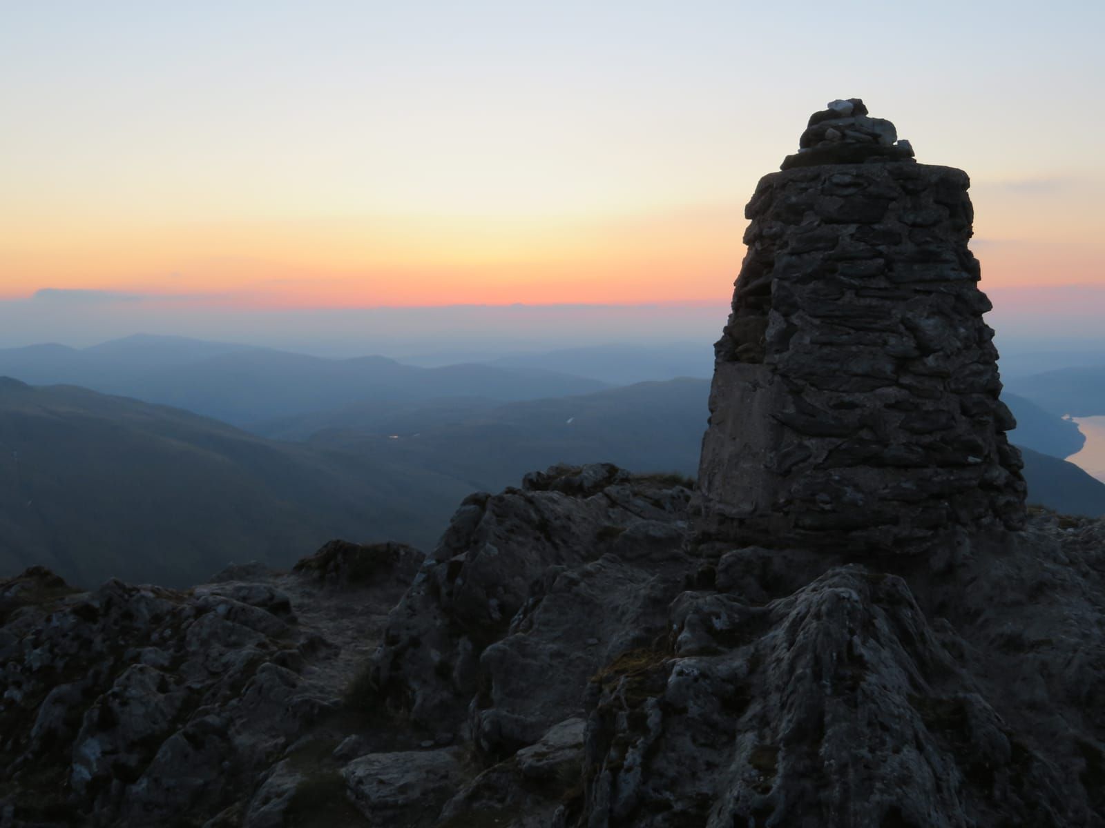
Step 5: The Summit The summit of Ben Lawers is crowned by a large cairn and a trig point (now somewhat ruined). On a clear day, take your time here — the 360-degree panorama is one of the finest in Scotland. The summit plateau is broad and stony, with little shelter from the wind, so have your windproof layers ready.
Step 6: Return by the Same Route (2–2.5 hours) Most walkers descend by the same route. The re-ascent of Beinn Ghlas on the return can feel surprisingly tiring, so allow for this in your planning.
The Seven Munros of the Ben Lawers Range
Ben Lawers is actually the highest point of a long mountain ridge that contains seven Munros — one of the richest concentrations of high peaks in Scotland. For serious Munro-baggers, the full ridge traverse is a magnificent but demanding expedition:
- Meall Greigh (1,001m) — The eastern end of the ridge, often climbed from Lawers village
- Meall Garbh (1,118m) — A rocky peak with a sharp summit ridge
- An Stuc (1,118m) — The most technical summit, involving a steep, exposed scramble that is a serious proposition in winter
- Ben Lawers (1,214m) — The highest point and the centrepiece
- Beinn Ghlas (1,103m) — The “green peak,” climbed on the standard route
- Meall Corranaich (1,069m) — A rounded summit to the west
- Meall a’ Choire Leith (926m) — The western terminus of the ridge
The full traverse from Meall a’ Choire Leith to Meall Greigh (or vice versa) covers roughly 20 km with over 2,000m of ascent and takes 10–14 hours for fit walkers. It requires careful logistics (a car at each end or a long walk back along the road) and should only be attempted in good conditions by experienced hillwalkers. An Stuc’s north face, in particular, demands respect — in winter conditions, it requires crampons, an ice axe, and winter mountaineering experience.
The National Nature Reserve
The Ben Lawers National Nature Reserve covers 9,500 hectares of mountain, moorland, and woodland on the northern flanks of the range above Loch Tay. Managed by the NTS since 1950, it was one of the first National Nature Reserves declared in Scotland and remains one of the most important.
The NTS Visitor Information
The NTS maintains information boards and interpretation materials at the car park, providing valuable context about the geology, ecology, and history of the area. These are worth reading before you set off — understanding what you’re looking at dramatically enhances the experience. The NTS also runs guided walks during the summer months, led by rangers with expert knowledge of the mountain’s flora and fauna. These are highly recommended and often reveal plants and wildlife that you would walk straight past on your own.
The Nature Trail
The NTS has created a lower-level nature trail from the car park that explores the botanical riches of the lower slopes without any serious climbing. The trail follows a circular route through habitats including montane grassland, calcareous flushes, and heather moorland, with interpretation boards identifying key plant species.
- Distance: Approximately 2 km
- Time: 1–1.5 hours (more if you stop to examine plants)
- Grade: Easy, though the ground can be wet
- Best time: June–July for the widest variety of flowers in bloom
This trail is ideal for families, less mobile visitors, or anyone with a particular interest in botany. It gives a genuine flavour of what makes Ben Lawers special without requiring a full mountain day.
Winter Walking on Ben Lawers
In winter, Ben Lawers transforms into a serious mountaineering proposition. Snow typically covers the summit from November to April (sometimes later), and the mountain’s northern corries accumulate deep snowfields that persist well into spring.
Winter Conditions
- Snow and ice: The path to Beinn Ghlas and onward to Ben Lawers can be snow-covered and icy from November onwards. Crampons and an ice axe are essential, and you must know how to use them.
- Navigation: Cloud cover is common in winter, and the broad, featureless plateaus near the summit become extremely disorienting in whiteout conditions. Compass and map navigation skills are essential. GPS is helpful but should not be relied upon as your sole navigation method.
- Daylight: In December, there are fewer than 7 hours of daylight. An early start is essential to complete the route safely.
- Wind chill: Summit temperatures with wind chill can plunge below -20°C in winter. Full winter mountaineering clothing is required, including insulated layers, windproof shell, balaclava, goggles, and spare gloves.
- Avalanche risk: The northern corries and steep slopes below An Stuc are avalanche-prone after snowfall, particularly when wind-loaded. Check the Scottish Avalanche Information Service (SAIS) forecast before any winter outing.
- An Stuc in winter: The scramble up An Stuc becomes a Grade I/II winter climb in snow and ice conditions. It should only be attempted by experienced winter mountaineers.
Winter days on Ben Lawers, when conditions allow, are among the most spectacular experiences in the Scottish mountains. The combination of snow-covered summits, frozen lochs far below, and vast views to distant snow-capped ranges is unforgettable.
Photography Tips
Ben Lawers offers outstanding photographic opportunities in every season:
- Golden hour from the summit: The summit panorama in the hour after sunrise or before sunset is extraordinary. In summer, this means very early starts or late finishes — but the light on Loch Tay and the surrounding mountains is worth it.
- Alpine flowers: A macro lens (or close-focusing capability) is essential for capturing the mountain’s botanical treasures. Get down low and use a wide aperture to isolate individual flowers against a blurred mountain backdrop.
- Inversions: Ben Lawers is high enough to sit above temperature inversions, when cloud fills the glens below while the summits bask in sunshine above a sea of white. These conditions are most common in autumn and winter, and produce some of the most dramatic photography possible in Scotland.
- The loch from above: The view down to Loch Tay from the Beinn Ghlas ridge is one of the finest perspectives on the loch. In still conditions, the mountain reflections in the loch are visible even from 700m above.
- Winter drama: Snow, ice, and dramatic cloud formations create powerful images. A polarising filter helps with snow contrast, and graduated ND filters balance bright snow against darker skies.
Nearby Munros: The Meall nan Tarmachan Circuit
Just to the west of Ben Lawers, and accessed from the same minor road, is the Meall nan Tarmachan horseshoe — a superb ridge walk that offers a contrasting experience to the Ben Lawers massif.
- Start point: The car park on the minor road at approximately NN 604 382
- Distance: 10 km circular
- Ascent: 700m
- Time: 5–6 hours
- Munros: 1 (Meall nan Tarmachan, 1,044m), plus three Tops
The route follows a dramatic, airy ridge with some mild scrambling, traversing over the summit of Meall nan Tarmachan before continuing along the ridge to the subsidiary tops of Meall Garbh, Beinn nan Eachan, and Creag na Caillich. The views throughout are superb, and the ridge has a more dramatic, exposed character than the broader slopes of Ben Lawers itself.
This circuit is an excellent choice for a day when cloud is higher than the Ben Lawers summit, or as a second-day objective to complement a Ben Lawers ascent. The scrambling sections are straightforward in summer but require care in wet or icy conditions.
Safety Advice
Ben Lawers is a serious mountain. Even in the gentlest summer conditions, you should treat it with respect:
- Weather changes fast — Cloud can descend within minutes, reducing visibility to a few metres. Always carry full waterproofs and warm layers, even on the brightest summer day.
- Navigation skills — Carry a map (Harvey Superwalker or OS 1:25,000) and compass, and know how to use them. GPS is helpful but batteries fail and signals can be unreliable.
- Clothing — Full waterproofs, warm layers, hat, and gloves even in July. The summit can be 10–15°C colder than the car park.
- Footwear — Proper hillwalking boots with ankle support and good grip, not trainers or fashion boots.
- Food and water — Carry more than you think you’ll need. There is no shelter or refreshment on the mountain.
- Tell someone — Leave your route plan with someone who isn’t on the hill, including your expected return time.
- Start early — An early start gives you the best chance of clear weather (cloud often builds during the day) and allows margin for delays.
- Turn back if conditions deteriorate — The mountain will always be there another day. There is no shame in turning back.
Getting There
The NTS car park is on the minor road between the A827 (Loch Tay north shore road) and Bridge of Balgie (Glen Lyon). From Killin, drive approximately 6 miles east along the A827, then take the signed turn-off uphill to the south. The car park is about 3 miles up this single-track road. From Kenmore, head west on the A827 for approximately 8 miles.
The car park charges a small fee for non-NTS members (free for NTS members). It can fill up on fine weekends and bank holidays, so an early arrival is advisable. There are no facilities at the car park — the nearest toilets and refreshments are in Killin or Kenmore.
Best Time to Visit
- June–July — Alpine flowers at their absolute peak. The longest days give maximum time on the hill. Snow has usually melted from the main paths (though late patches can linger in north-facing corries).
- September — Quieter than summer, with the deer rut beginning on the lower slopes (an extraordinary spectacle to witness from a safe distance). Autumn colours starting on the lower hillsides.
- October — Golden autumn light, minimal midges, and dramatic skies. The mountain begins to feel wilder and more wintry.
- Clear winter days — Spectacular snow-covered views and a genuine sense of mountain adventure. Experienced hillwalkers only.
- Avoid — Low cloud days (you’ll see nothing from the top, and navigation becomes challenging). Check the Mountain Weather Information Service (MWIS) forecast before committing to an ascent.
Ben Lawers is one of those mountains that rewards repeated visits. Each season brings different plants, different light, different weather, and different wildlife — and the view from the top, when the clouds part to reveal half of Scotland spread out below you, never gets old. It is a mountain that has drawn walkers, scientists, and nature lovers for over two centuries, and it continues to inspire everyone who makes the effort to climb it.