Ben Lawers Nature Trail
An easy, family-friendly loop exploring the remarkable alpine flora of the Ben Lawers National Nature Reserve.
Popular guides
More outdoors
Find by type
Our favourites
Makers & artisans
Shops & local produce
Challenging walk
The classic Munro route up Scotland's 10th highest peak, with two summits and stunning views across the Highlands.
Distance
8.5 km
Duration
5-6 hours
Ascent
870m
Route type
out-and-back
Parking
NTS car park (small fee for non-members)
Ben Lawers (1,214m / 3,983ft) is the highest peak in the southern Highlands and the tenth highest mountain in Scotland. Bagging it is one of the defining Loch Tay experiences — a serious but deeply rewarding mountain day that takes you through some of the richest alpine habitat in Britain and delivers two Munro summits and some of the most expansive views in the country. This classic route climbs Beinn Ghlas (1,103m) first, then continues along a high ridge to Ben Lawers itself.
The walk begins from the National Trust for Scotland car park on the mountain road that connects the A827 (Loch Tay north shore road) with Bridge of Balgie in Glen Lyon. The turn-off from the A827 is about 6 miles east of Killin and is signed for Ben Lawers. Follow the single-track road uphill for approximately 2.5 miles to reach the car park on your left, at an altitude of roughly 450m.
A small parking fee applies for non-NTS members (around £3 at the time of writing — check the honesty box or pay machine). NTS members park free. The car park has space for perhaps 30 cars and fills up on fine summer weekends and bank holidays — arrive before 9am to guarantee a space. There are no toilets or other facilities at the car park, so come prepared. A large information board at the trailhead shows the route and provides safety information.
From the car park, pass through the gate and follow the well-constructed stone path heading north. The path is broad and clear, climbing gently across open hillside. You’re already in the Ben Lawers National Nature Reserve, and in summer the grassland either side of the path is alive with wildflowers. Interpretation boards along this lower section explain the geology of the mountain — the calcium-rich Dalradian schist that gives Ben Lawers its extraordinary botanical diversity.
After around 500 metres, you’ll pass the nature trail loop branching off to the right. If you’re here for the summit, continue straight ahead on the main path. The nature trail is a separate, shorter walk described in our Ben Lawers Nature Trail guide.
Beyond the nature trail junction, the path begins to climb more purposefully. It’s well-built with stone pitching on the steeper sections — the work of NTS path teams who maintain this route to a high standard to protect the fragile montane vegetation.
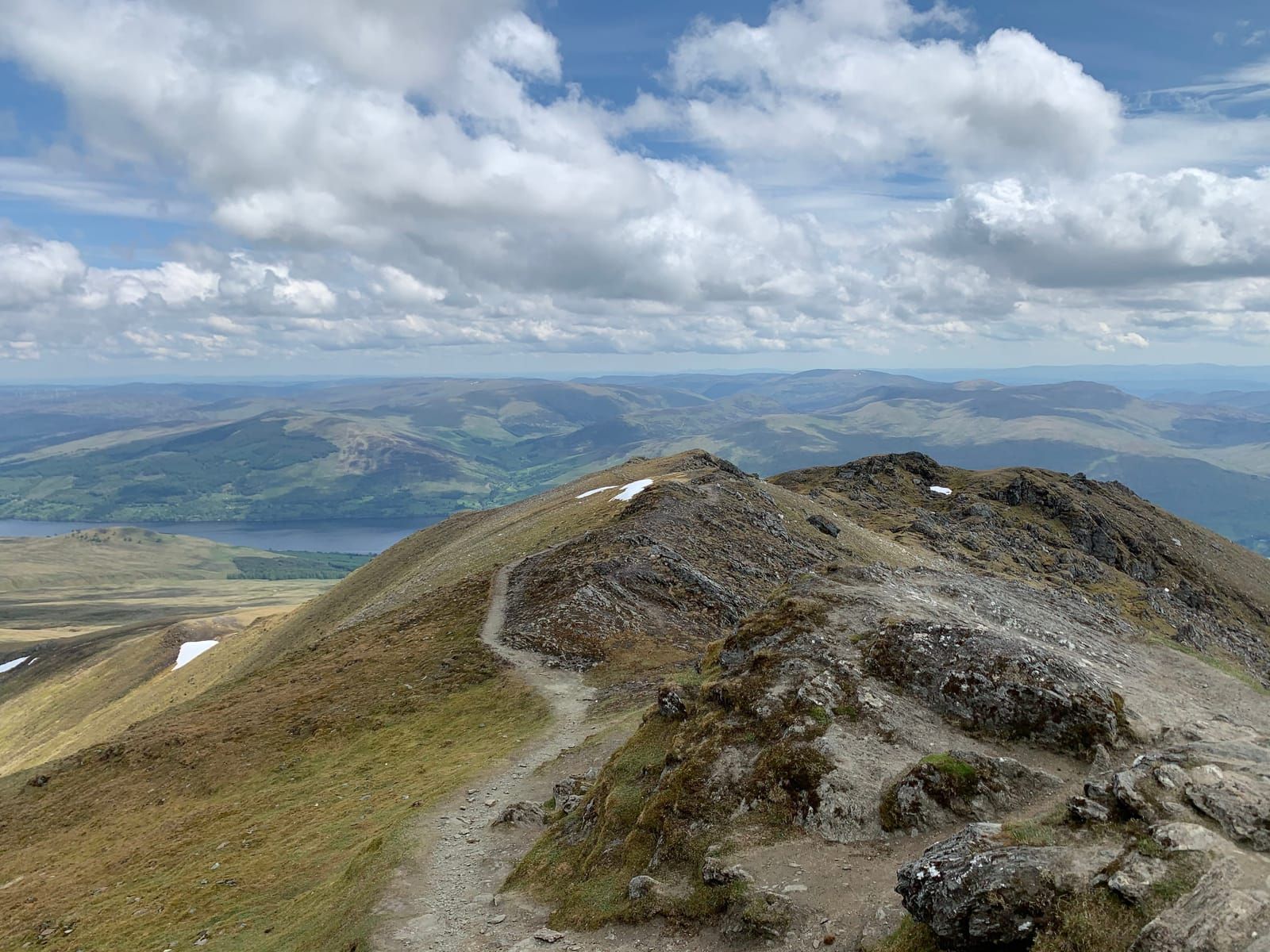
As you gain height, the views south open up dramatically. Loch Tay unfurls below you, a long silver ribbon stretching 14.5 miles eastward to Kenmore. On the far shore, the rolling hills of the Tarmachan ridge run along the skyline. The higher you climb, the more of the southern Highlands falls into view — the peaks above Glen Dochart, the distant Trossachs, and on clear days the flat shimmer of the Forth estuary.
The gradient steepens as you approach the upper slopes of Beinn Ghlas. The path zigzags up the south face, gaining height steadily. The ground becomes rockier, the grass shorter and more wind-clipped. In June and July, look carefully among the rocks for mountain pansy (Viola lutea), with its cheerful yellow and purple faces, and the tiny white stars of alpine mouse-ear (Cerastium alpinum).
The summit of Beinn Ghlas arrives almost unexpectedly — the path levels out, and suddenly there’s a cairn and the ground drops away to the north. At 1,103m, this is your first Munro of the day. Take a moment here. The view south over Loch Tay is magnificent, and to the north, the bulk of Ben Lawers rises ahead of you, looking deceptively close but with a significant dip between.
Estimated time from car park to Beinn Ghlas summit: 1.5–2 hours.
This is many walkers’ favourite section — a high-level ridge walk with exposure and drama. From the Beinn Ghlas cairn, descend north on a clear but rockier path into the col (bealach) between the two mountains. You drop about 100m of height into this saddle, and the terrain is stony and sometimes loose underfoot.
From the col, the broad south ridge of Ben Lawers rises ahead. The path climbs steadily, becoming rockier as you gain the upper mountain. Cairns mark the way at intervals. The final section before the summit is a boulder field — large, stable rocks for the most part, but requiring care in wet or icy conditions.
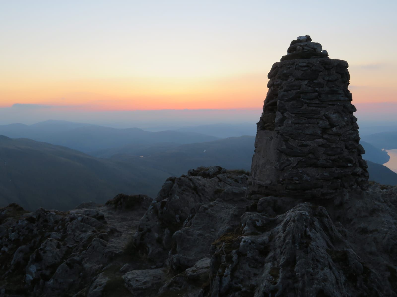
The summit of Ben Lawers is marked by a trig point and a large stone shelter cairn. At 1,214m, you’re standing on the highest point for many miles in every direction, and the 360-degree panorama is extraordinary.
Estimated time from Beinn Ghlas to Ben Lawers summit: 1–1.5 hours.
On a clear day, the views from the top of Ben Lawers are among the most extensive in Scotland. Here’s what you can see:
Return by the same route — back over Beinn Ghlas and down to the car park. The descent of Beinn Ghlas’s south face requires care, as steep paths are always harder on the knees going down. Walking poles are a great help on this section. Some experienced walkers descend via the eastern corrie to create a loop, but this route is pathless, involves steep grass, and is significantly harder to navigate in poor visibility. It is not recommended for those unfamiliar with the mountain.
Estimated total round trip: 5–6 hours for fit walkers. Allow 7 hours if you’re taking a relaxed pace with stops.
Ben Lawers is designated a National Nature Reserve and a Site of Special Scientific Interest primarily for its arctic-alpine flora. The calcium-rich bedrock supports plant communities found almost nowhere else in Britain at this scale. The best months for flowers are June and July, when you may see:
Higher up, the ground is home to woolly hair moss, stiff sedge, and various lichens that crust the summit rocks. This is genuinely one of the most important botanical sites in the UK.
Beyond the plants, keep an eye and ear out for:
This is a serious mountain walk and you must be properly equipped:
In winter, Ben Lawers is a full winter mountaineering route. Snow typically covers the upper mountain from November through to April, and the path can be buried under deep snowdrifts. The summit ridge and the descent from Beinn Ghlas can be icy and corniced.
You will need:
Do not attempt the summit in winter unless you have winter hillwalking experience. The mountain claims injuries every year from unprepared walkers. Check the Scottish Avalanche Information Service (SAIS) forecast for the Southern Highlands before setting out.
New guides, seasonal tips, and the odd hidden gem — straight to your inbox. No spam.
We respect your privacy. Unsubscribe anytime.